Here’s the continuation of our fun weekend in the Rockies. After Saturday Brenda and I decided to invite our good friend Liliana for a Sunday Nordic ski day.
Our decision was not easy as the trail conditions in Peter Lougheed Provincial park as well in the Ribbon Creek area were good according to Skier Bob’s report page.
I highly recommend his and other skiers posts about the trail conditions.
We decided to ski this day on the “Goat Creek” and “Spray Lakes” trail. These two trails combined create a connector trail in between the Trail Head at the Smith Dorrian/Spray trail, about 8km south of Canmore. This trail location is also used to access the hiking trail for “East End of Rundle” and “Ha Ling Peak“. Both superb scrambles in summer.
The trail is usually skied one way from Canmore to Banff as a downhill run and a second vehicle is left at the “Spray River” trail head in Banff at the Fairmont Banff Springs Hotel. Another option is to ski from Canmore to Banff, spend the night in Banff and return to Canmore the next day. This option is still in our plans for this season.

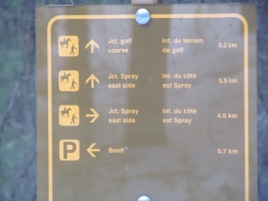
Here are the stats

Distances to intersections
We decided differently: We challenged ourselves to start in Banff and ski the entire return to Canmore and back. The entire length of this ski is 37.2 km with a elevation change of 611 m. From Banff the trail climbs 435 m and descents 176 m.
We left Calgary at 9:20 and after an entertaining drive we arrived at the trail head just passed the Fairmont Springs hotel at 10:30. The temperature was pleasant and we had partially cloudy skies. The parking lot itself was not very busy as the favorite start of this trail is in Canmore.

We commenced with high spirits at 10:50 with a good speed of 6.4 km/h until the campground SP 6 ,5.9 km from the trailhead in Banff.

Some Ice along the bank
The trail follows a slight uphill from the parking lot along the beautiful Spray river, until the intersection with the “Goat Creek” trail 9.9 km distance from Banff. From there the trail turns east and descents to the “Spray River” bridge, continues uphill and again downhill to the “Goat Creek” bridge. We had great conditions, with some slight ice covering the tracks which made for faster gliding speed and hard packed snow with some loose snow in the centre section,which made steeper ascents easier. We actually did not feel as if we are ascending much, due to the slight elevation gain until the Spray River bridge. From there the grade chances quite drastically.

Goat Creek junction

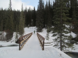
At Goat Creek bridge. 9.5 km from Banff
The ascent after Goat creek Bridge
We arrived at the Goat Creek Bridge at 12:20 after 9.5 km and a time of 1 hr and 36 min. We took some time to take a few pictures and went on.
From here we ascended over various grades until 1.7 km from the Canmore side trail head. The trail from here varies from a trackless bowl-shaped initial ascent, to track sets in both direction combined with 1 foot high center mounts on the trail. We really inspected the trail as we will return to Banff the same way.

Happy almost half way done
During our way to Canmore we were passed by a few faster skiers returning from their overnight stay in Banff as well as some skiers which returned from the Goat creek Junction 10.5 km from Canmore.
At 13:56, after 3 hrs and 16 minutes and 16.9 km we arrived at the Sign which seperates the Nordic Ski trail from the snow show trail at 1.7 km from the Canmore trail head.
From here on the trail is no longer track set and is used by walkers, snow shoe users as well as skiers. Caution is a must as the trail descents with an icy surface and it is quite narrow.
A few Minutes later we arrived just below the parking lot at the Canmore side situated below “Ha Ling” and “East End of Rundle”.
There we enjoyed our lunch with Soup and sandwiches, a cup of tee and congratulated ourself that we conquered the 18.6 km from Banff. Now we just had to return to Banff, which would be the easier part as most of the trail descents towards our starting point.

Our Half Way point Ha Ling in background

Brenda and I at half way point
During our lunch more and more skiers arrived back here after their return trip from Banff or the Goat Creek bridge.
At 14:30 we commenced our return journey which we treated as the beginning of our Journey for psychological reasons.
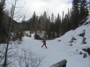
Challenging descent back to Goat Creek
We arrived at the Goat creek bridge after 5.1 km at 15:26. The descent towards the bridge was a little challenging as the trail was icy and the steepest part was bowl-shaped which made a controlled slow descent a bit harder than under better conditions.
From here we continued to the Spray River bridge and we arrived at 15:45.
After this point is a slight uphill up to the intersection with Spray Lakes trail, and then the trail flattens out and is mostly downhill towards Banff. We arrived at the junction at 15:50.
I actually realized shortly after this point that I did not carry enough food and water with me for a longer trip as this. The amount of 2 liters which I carried was depleted and I soon felt the consequences, as my energy level dropped quite significantly due to light dehydration.

Brenda and Liliana
Despite this our spirits stayed high and we were just happy to be out enjoying this wonderful day. The ladies even showed some goofiness.

5.9 km from start point again
The trail and it’s conditions made the return quite easy as we glided most of the way. The sun was in our back, the mountains were glimmering and the temperature was perfect.
Soon (16:23) we arrived at the SP 6 campground again 5.9 km from the End of our journey.
0.7 km back to Banff
Our speed dropped back to about 5.6 km/h which still made a fast return back to our origin easy. Liliana, our most energetic skier charged ahead and Brenda and me arrived shortly after at the best sign on the trail so far.
At this junction we could have skied east side of the spray river towards Canmore but we elected to stay on the west side as the east side is also used by equestrians.

My standing fall at trail head
We finally arrived back at the beginning of our adventure at 17:15. And there of course just 2 meters from the end I slowed down, crossed my skies and had the classic standing fall.

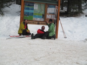
Victorious three
After 6 hrs and 2 minutes we arrived back at our car and it was definitely time to celebrate.
At Banff trailhead
Here again just some stats: Total Distance: 37.2 km.
Elevation Gain: 611 m
Elevation Loss: 270 m
Total ski time: 6 hrs and 2 Min
Average speed: 6.20 km/h
After this great Nordic ski we returned to the great town of Canmore and enjoyed and high calorie meal at “La Belle Patate“, consisting of a large Poutine Supreme and a Spruce Beer float. Definitely My favorite meal after a long day in the mountains.

 After waiting for several years to finally realizing my dream to be working in the outdoors, the National Parks and especially the Rocky Mountains I reached my goal and will be working as a professional hiking guide for the well renowned company : Timberwolf Tours in Spruce Grove AB.


